
Everyone knows the Stelvio Pass. But do you know the south side of the Vršič?
Some passes people talk about. Others, you talk about afterward.
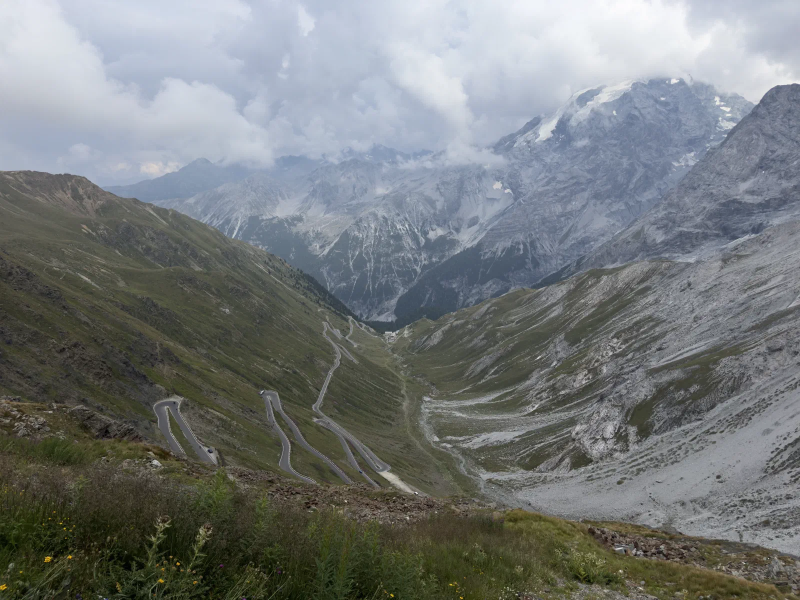
The Stelvio is the first kind. 48 hairpins on the Prato side, every one of them numbered, with signs that count you down like a NASA launch. Everybody’s seen the photo: switchbacks draped down the mountainside like an extension cord somebody tossed aside. Everybody’s been there or wants to go. On a Saturday there are more GSs at the top than on a dealer’s lot. I know. I was one of them.
Anyone planning a pass ride has the names in mind. What’s usually missing is the number that goes with them. Late this summer the developers stepped away from the code, got some lean angle in, and came back with a table. No postcard shots, no elevation stats, no legends. Just road. How often it turns you around, how much of it is curve and how much is straight. Sober, clean, ruthless.
And suddenly the king of the Alps wasn’t sitting on top anymore.
Measuring curves, minus the poetry
Picture riding a road and keeping a running tally of how many degrees your heading changes in total. A hairpin turns you almost all the way around, a long left-hander maybe 60 degrees, a straight not at all. At the end, you divide the total by the kilometers. Out comes one number: degrees of turn per kilometer.
360 degrees per kilometer means you do one full 360 every kilometer. Sounds harmless. Until you ride it.
Then there’s the curve share: what percentage of the distance you actually spend in a curve, and how much of it is just the approach.
That’s all it takes. No myths, no barstool math. Two numbers that don’t lie.
The rankings
| Road | Length | Turn per km | Curve share |
|---|---|---|---|
| Vršič, south side (from Trenta) | 12.2 km | 691° | 48% |
| Mangart Road (up to the gate) | 9.0 km | 612° | 38% |
| Vršič, north side (from Kranjska Gora) | 12.3 km | 569° | 39% |
| Silvretta High Alpine Road | 20.4 km | 473° | 30% |
| Stelvio Pass, north side (from Prato allo Stelvio) | 25.5 km | 456° | 25% |
| Transalpina, north side (from Obârșia Lotrului) | 21.7 km | 409° | 39% |
| Stelvio Pass, south side (from Bormio) | 21.4 km | 403° | 28% |
| Gavia Pass, from Santa Caterina | 14.1 km | 383° | 32% |
| Nockalm Road | 33.5 km | 382° | 22% |
| Transfăgărășan, north side (from Cârțișoara) | 30.1 km | 355° | 39% |
| Gavia Pass, from Ponte di Legno | 17.8 km | 350° | 30% |
| Grossglockner High Alpine Road | 46.1 km | 336° | 26% |
| Predel Pass, Italian side | 5.4 km | 326° | 34% |
| Timmelsjoch, both sides | 39.5 km | 322° | 22% |
| Transfăgărășan, south side (from Lake Vidraru) | 53.5 km | 311° | 38% |
| Transalpina, south side (from Novaci) | 28.6 km | 242° | 25% |
To go: every pass on the list as points for MotoNavigator. Download, tap, plan.
The Stelvio: long, legendary, watered down
Don’t get me wrong. The Stelvio is a monument. Ride the north side up and you go all the way around roughly 32 times in total. It’s got volume, no argument there.
But the climb is long. Between Prato and the first real hairpins there are kilometers where the road is just clearing its throat. Per kilometer, that works out to 456 degrees. Strong, no question. But not number one.
The Stelvio is like a concert by a band you’ve been following for thirty years: you know what’s coming. And that’s exactly why you go.
Austria: the Glockner is the stage, the Silvretta is the show
The Grossglockner High Alpine Road: 48 kilometers, 36 hairpins, a view of the country’s highest mountain. A road with all the pomp of a state dinner. But per kilometer it lands in the back half of the pack - too much panorama, too much road between the hairpins. You don’t ride the Glockner for the curves. You ride it because it’s on the bucket list.
The surprise lives farther west. The Silvretta High Alpine Road packs 34 hairpins into a little over 20 kilometers, most of them on the Vorarlberg side, stacked on top of each other like plates in a dishwasher. 473 degrees per kilometer - more than the north side of the Stelvio.
The Nockalm Road in Carinthia is the flip side: 52 hairpins, but wide, sweeping, friendly. A pass for rhythm, not for brakes. The Timmelsjoch, 44 hairpins from the Ötztal Valley over into South Tyrol, trails it on the numbers - and is still one of the most beautiful border crossings Europe has to offer.
Romania: the best road in the world?
At some point a British TV show about cars declared the Transfăgărășan the best road in the world, and half of Europe has been making the pilgrimage to the Carpathians ever since. Built in the ’70s on the orders of a dictator who wanted a road for his tanks. What came out of it was a motorcycle dream. So much for history going according to plan.
The north side from Cârțișoara up to Bâlea Lake is a waterfall of asphalt: 355 degrees per kilometer, almost 40% curve share, well over 80 hairpins along the whole road. The south side, meanwhile, drags on forever along Lake Vidraru. Scenic, long, sleepy.
And then there’s its quiet brother. The Transalpina, Romania’s highest road, lives in the Transfăgărășan’s shadow and is twistier on its north side: 409 degrees per kilometer. Less Instagram, more road.
Both are only open in summer, roughly from July into the fall. The rest of the year, the mountain belongs to the snow.
The Vršič: the winner
And then Slovenia.
The Vršič links Kranjska Gora with the Soča Valley. 24 hairpins on the north side, 26 on the south, every one of them numbered, many of them cobblestone. The north side is called the Russian Road, built during World War I by Russian prisoners of war. You don’t just ride through there. You ride through history.
The south side down to Trenta is the real knockout: 691 degrees per kilometer. Almost two full turns in every single kilometer. For nearly half the distance you’re leaned over in a curve. That’s not a pass anymore. That’s a corkscrew.
The best part: if you’re headed from Kranjska Gora to Bovec and only watching the clock, you don’t take the Vršič at all. The faster way runs through Italy, over the Predel. Over the Vršič, the same trip costs you about a fifth more riding time. What you get for it: better than four times as many hairpins.
The Vršič is the detour you leave home for.
The Mangart Road: a bonus for those in the know
If you’re at the Predel, take the turnoff. Otherwise you’ve missed something.
The Mangart Road climbs toward the Mangart Saddle, the highest road in Slovenia. Toll road, 17 hairpins, a handful of unlit tunnels hacked roughly into the rock. The last stretch up to the saddle belongs to cyclists and hikers these days - for us, it ends at the gate. No big deal. Helmet off, eyes up, the last few meters on foot.
Up to there: 612 degrees per kilometer. On a road barely wider than a GS with aluminum side cases. Don’t ask how I know.
And the Mortirolo?
That one was on our list too. The famous side from Mazzo, the one from the Giro d’Italia, would have been right up there at 656 degrees per kilometer.
Would have. In a lot of places the road is barely three meters wide, the pavement is tired, and in the summer of 2025 the town closed the eight kilometers up from Mazzo to cars and motorcycles - local traffic only (as of September 2026). You can still ride up from Grosio or Monno. The legendary side belongs to the cyclists. They’re welcome to it.
The takeaway
The most famous passes aren’t the twistiest. They’re the most famous. That’s not the same thing.
The Stelvio has the volume. The Grossglockner has the name. The Transfăgărășan has the reputation. The Silvretta has the hairpins. And the Vršič has the density - its south side crams all of it into twelve kilometers.
One more tip: a lot of these roads charge a toll, some are only open in summer, and the Stelvio and the Gavia are closed to motorcycles on certain mornings (as of September 2026), when the road belongs to the cyclists. Check before you go. Saves you the grief.
Next summer, when you’re stuck in line on the Stelvio again, behind an RV from Scranton and in front of three GS riders in identical helmets: think of Slovenia. Hardly any traffic, plenty of curves, good beer.
Tight, old, honest.